From Carnegie Magazine, January 1964, Point State Park,
Birthplace of Pittsburgh, by Charles M. Stotz.
Assuming its place among the leading city parks in
the world, Pittsburgh's new park at The Point will be unique in its
dramatic setting and historical significance; for this little triangle of
land was brought into sharp international focus in the mid-eighteenth
century when it became a prize of critical importance in the worldwide
contest between France and England.
To protect their possessions, extending inland from Quebec to New
Orleans, the French here made their decisive move to intercept English
westward expansion. By seizing the Virginians' little Fort Prince George
in 1754 and by building Fort Duquesne on its site, the French established
control of the Ohio valley until 1758. For these four years, this little
settlement was a French town that Louis XV hoped to make the permanent
capital of his lands beyond the Allegheny Mountains.
After two major military expeditions, the English routed the French and
hastily constructed a small temporary fort to secure their hard-won
prize. The English had realized, belatedly, that the Ohio River, born at
the tip of this triangle, was the open road
to the vast interior of the continent; and that the nation controlling
this natural highway controlled the future of the land. Hence they
proceeded to build their most substantial and costly stronghold in
America, naming it Fort Pitt and the place Pittsburgh in honor of the
prime minister in London who had finally brought success to British
arms.
It transpired that the Forks of the Ohio nourished the seeds of a great city. These hills with their rich minerals and these broad rivers were the source of Pittsburgh's ever increasing eminence in transportation, commerce, and industry. It was inevitable that the people should eventually seek to make a suitable memorial at the meeting of the Allegheny and Monongahela rivers. The present realization of this hope is the subject of this short essay.
Beginning in 1838, when Mayor Jonas E. McClintock's proposals to build
a memorial park at The Point were frustrated by the demands of river and
land traffic, successive generations sought to achieve this end; the
project has had more plans offered for its solution over the years than
any other in the Pittsburgh region. The Point remained in modern times a blighted area containing several hundred
nondescript buildings and a sprawling freight terminal that surrounded
and submerged the one simple, distinguished remnant of our first days--the Blockhouse. This redoubt, one of five that
originally stood on the perimeter of Fort Pitt, is the oldest
authenticated structure in western Pennsylvania. Miraculously preserved
from its construction in 1764, it has been saved
for us by the Daughters of the American Revolution and will, of
course, be the brightest jewel in the new park setting.
Finally, in 1945, the Pittsburgh Regional Planning Association under the
leadership of Richard K. Mellon authorized Charles M. Stotz and Ralph E.
Griswold to make the definitive study of the lower-triangle area that
established the essential features of the park. Their plans, refined
through subsequent studies over the intervening years in association with
the firm of Clarke and Rapuano, form the basis of the working drawings
and specifications shortly to be issued by the General State Authority to
contractors for bidding.
This successful culmination of The Point project was the product of
many hands, working in harmony over the years toward a single end. Other
cities and countries have marveled at the many accomplishments--of which
Point Park is but one--of the guiding organization, the Allegheny
Conference on Community Development, and have sent delegations to
Pittsburgh or have asked that representatives of the Conference visit
them to learn how we in Pittsburgh have accomplished so much in the years
since the last war. The Conference at the request of Governor Edward
Martin established the Point Park Committee in 1945 to lead The Point
project to its successful conclusion. Composed of leaders in business,
industry, and commerce as well as the heads of city, county, and state
governments, this Committee has served without personal or political
prejudice or discord under the able chairmanship of Arthur B. Van Buskirk
since its formation.
Following the seventeenth meeting of the Point Park Committee on November
19, 1963, the newspapers carried the message that all of Point Park would
shortly be under construction except the area occupied by the Point and
Manchester Bridges. Plans are now in progress for completion of the
Allegheny approaches to the Fort Duquesne Bridge. When these are
completed, some three years hence, the old bridges at The Point will be
removed. Then the final pool and great
fountain can be built at the very tip of the triangle, and Point
State Park will at last be completed.
At the very beginning the basic decision was made to maintain a
simple, unified park of monumental sweep, uncluttered by buildings and
monuments or any graveyard of memorials and statues. The hills and
rivers, little changed by man since the early days, provide a majestic
memorial far more impressive than any man-made monument.
The park design recognizes three basic elements: the highways, the
rivers, and the fort sites. While considering the aesthetic and
historical aspects of the problem, it was vitally necessary to solve the
needs of modern traffic and of the living city. To provide the necessary
traffic interchanges it was found necessary to remove the bridges at The
Point and build new and more adequate ones some nine hundred feet
upstream. Regrettably, this made the full-scale total restoration of Fort
Pitt impossible, but it did provide an eighteen-acre, open, park area at
The Point itself and another eighteen-acre park area between the highway
structures and Gateway Center. Of the five original bastions, the Flag
Bastion was restored about five years ago, and the Monongahela Bastion is
to be restored as a museum, chiefly military, of local history up to
1800. The park was placed under the jurisdiction of the State Department
of Forests and Waters and has been thereafter known as Point State Park.
The Urban Redevelopment Authority, under the devoted leadership of the
then Mayor and later Governor David L.
Lawrence, interested the Equitable Life Assurance Society of New York
in acquiring some twenty-three acres of land adjacent to the park, and
constructing Gateway
Center. The buildings in the Redevelopment area include Gateway
Center's four units, the Hilton Hotel, the State Office Building, the
International Business Machines Building, Bell Telephone Building, the
new Gateway Towers apartments. These tall buildings form the backdrop of
Point State Park.
The aerial view on the cover [not shown] shows the plan layout of the
park and its relationship to the traffic system and the downtown triangle
buildings. The entire park will be at the original level of the site.
Point State Park begins in front of the Hilton Hotel at Commonwealth
Place, from each end of which two broad curving walkways lead to the
vaulted opening known as the Portal beneath the highway. The Portal forms
the sole entrance to and exit from the park for pedestrians and for the
vehicles required in park maintenance. No passenger automobiles are
permitted in the park. These two walkways enclose, on the eastern segment
of the park, the Music Bastion of Fort Pitt. This bastion will not be
restored; instead, the ground will be excavated to expose the existing
foundations of the original brick walls of Fort Pitt. this depressed area
will be accessible by a staircase at each end, so that visitors may
examine this relic of the past at close hand. There is a broad plaza at
the eastern end of the Portal, flanked by flags of the United States and
Pennsylvania. Large forest trees at each side of the eastern section of
the park will conceal the elevated highway except at the Portal.
The Portal, now completed, consists of three vaults, 160 feet long and 22
feet high. These vaults will be brilliantly illuminated from within by
six powerful floodlights located at the base of the vaults. The entire
area beneath the Portal vaults will be occupied by a shallow pool with
decorative mosaic surface that will be attractive when the pool is
drained in the winter. A slightly arched pedestrian bridge, forty feet
wide, spans the pool from the eastern to the western plazas of the Point
State Park.
The illustration [not shown] on page 16 shows the view looking back
toward the city with the Portal and western plaza on the left and the
Blockhouse and the Monongahela Bastion of Fort Pitt on the right. The
Blockhouse will remain unchanged on its present and original site. The
caretaker's house will be removed to give an open view of this precious
relic of the eighteenth century. The Monongahela Bastion will be
completely restored but, instead of using its original earth banks, it
will be faced with brick, similar to the bastions on the eastern face of
Fort Pitt. This is a practical necessity since this bastion will contain
the Fort Pitt Museum. It is of heavy concrete construction with four-foot
earth banks covering it.
When the visitor reaches the western plaza he may ascend a gentle ramp
to the top of the bastion, walk the ramparts, examine the cannon in their
embrasures, and view the surrounding landscape from the same vantage
point as the sentry of other days.
The cutaway view [not shown] shows the arrangement of the interior of the
museum. The visitor enters through a vestibule that is served by a gift
shop and the office of the caretaker of the Blockhouse, and thence into
the William Pitt Memorial Hall. This Hall
contains a bust of Pitt, various floor and wall decorations, a broad,
curving, mural painting at the end of the hall and, just in front of the
painting, a large scale model of Fort Pitt. This model will explain in
full detail the entire fort and its environs, the various outbuildings
and work areas, all animated with small figures of soldiers, animals, and
vehicles. From the Memorial Hall one enters the director's suite with its
offices and meeting room, and an exhibit area devoted to the history of
The Point area up to 1800.
Entering the museum from the Memorial Hall, one finds at the left a
meeting room or Information Center with 84 seats. Here, as at
Williamsburg, Virginia, an introductory program will be offered visitors
so that the exhibits may be more fully understood and appreciated. Regular
visitation will be arranged for school classes. The meeting room will
also be scheduled for small meetings of civic groups and varieties of
lectures, live and filmed. The drawing [not shown] shows the museum
exhibit area with its panels, cases, dioramas and special displays. The
study of the final arrangement and assemblage of these exhibits is now in
progress. The museum area is served by work and preparation areas for
curators and preparators, delivery, service, and heating and
air-conditioning facilities.
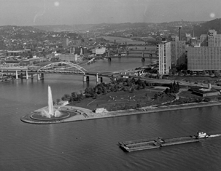
The picture on page 17 [not shown] shows a view toward The Point from
the elevated highway. Two areas of forest trees flank the broad sweep of
open lawn leading to the monumental 150-foot-high column of water formed
by the fountain in its basin at the tip of the triangle. This fountain,
symbolizing the water of the rivers that gave Pittsburgh its meaning,
will be the very climax and principal feature of the park design.
About halfway down the open area will lie the outlines of Fort Duquesne,
shown by paths of stone set in the lawn. The center of this tracery will
be occupied by a large circular bronze marker engraved with the plan of
Fort Duquesne taken from the only authentic drawing of the fort, now
preserved in the Bibliotheque Nationale in Paris. The stone-paved wharf
at the margin of the river has been completed for some years. Most
Pittsburghers have enjoyed the concerts of the Wind Symphony and other
presentations from the stone steps of the Allegheny River front. An
Overlook in the western section on the left of the Portal will afford a
vantage point from which visitors may look over the lower park and down
the Allegheny and Ohio rivers. The monumental scale of the park will not
be fully appreciated until the area is completely cleared and planted.
This brief presentation cannot include many interesting details of
the plans such as the use of music and special lighting effects at the
fountain. Studies are being made for the installation of a "light and
sound" program. This new idea, originated by Pierre Arnaud in Paris and
known there as "son et lumiere," has gained great popularity at historic
sites throughout the world. All plans have been aimed toward creating a
park that will be eminently usable and attractive to the people.
In the words of Secretary of Forests and Waters Maurice K. Goddard: "The
historic significance of Point Park symbolizes a milepost in our early
history...the spirit of the pioneer in planting Anglo-Saxon civilization
on the American frontier."