The Point: 1852
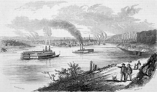
CAPTION: The Point, 1852.
NOTES: Engraving.
A closeup of The Point from this engraving.

"This manufacturing city, of which we give a representation
above, contains some fifty thousand inhabitants. The city stands
at the junction of the Alleghany and Monongahela Rivers, which,
by their union, form the Ohio. It is built upon the triangular plain,
enclosed on two sides by these two rivers, extending partly up the
highlands, by which the side opposite to the point is bounded. The
distance from the point back to these highlands is about one mile;
and the different prominences are known by the names of Grant's,
Ayer's, and Quarry Hills. The place was laid out in 1765, on the
bank of the Monongahela; with streets running parallel to the river,
and others running back from the river at right angles with them.
The same arrangement was followed when, afterwards, the town began
to be built upon the bank of the Alleghany; so that the cross
streets, starting at right angles from the two rivers, necessarily
meet obliquely, at a point a few streets back from the Alleghany.
Thus the city, in its outline, bears a strong resemblance to the
lower part of the city of New York. The city is united to the
adjacent country, beyond the two rivers, by a bridge over each,
and by ferries.

"The site, says a writer on the spot, is a real
amphitheatre, formed by the hand of nature. The rivers flow in
channels from 450 to 465 feet below the highest peaks of the
neighboring hills, which, by accurate measurement, have been found
to vary thus slightly between these relative elevations. These hills
surrounding the city are filled with bituminous coal, which is
easily quarried and brought to the city, and affords unequalled
facilities for manufacturing operations, for fuel, and for lighting
the streets and dwellings with gas. The principal coal strata lie at
an elevation of above 300 feet above the part of the city which is
on the alluvial plain; and so uniform is this geological feature,
that a levelling instrument, placed at the mouth of any of the beds,
if carried round the horizon, carries the circle of vision along the
openings of all the other mines. The coal formation is here, as in
every other part of the Ohio valley, level; so much so as often to
render the draining of the mines difficult. These hills, though
steep, are not generally precipitous, and afford from their verdant
slopes and peaks a series of rich and varied landscapes. The
fertility of the soil continues to their very summits. There is
nothing of barrenness visible, but the forests, fields, meadows,
orchards and gardens, exhibit one panorama of beauty and abundance.

"Pittsburg occupies the site of the former French fort Du Quesne,
which the French held possession of from 1754 to 1758, and whence,
by instigating the Indians to hostilities, they brought so much
terror to the frontier settlements of Pennsylvania. It was here in
1755, that General Braddock lost his life, and the army under him
suffered a defeat, in an attempt to drive the French from this post,
and that the youthful Washington displayed his military skill, and
gave promise of his future greatness, by conducting in a masterly
manner the retreat of the shattered forces. A subsequent expedition,
with a more formidable force, under General Forbes, was successful
in striking terror into the enemy, so they burned the fort and
abandoned the place...."
[Source for this engraving and accompanying description is unknown.]
PHOTOGRAPHER:
DATE: [1852].
HEADING:
#:
From the Collections of the Pennsylvania Department,
The Carnegie Library of Pittsburgh.
 mages 1.
 arrative.
 utline.
 eighborhoods.
 ain Menu.